Please be careful on your drive home today and check the weather report often. The following was taken from the WRAL.com website:
Winter storm's impact to vary across region
Posted: Today at 5:17 a.m. Updated: 1 minute ago
Raleigh, N.C. — Central North Carolina is bracing for a winter weather event Friday that will spread various combinations of snow, sleet and rain across the region.
"The winter weather is on the way, but different parts of the viewing area are going to see very different types of weather out of this system," WRAL meteorologist Elizabeth Gardner said.
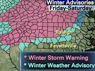
From Friday afternoon to Saturday evening, the western Triangle – including Durham, Orange and Chatham counties – is under a winter storm warning, while the eastern Triangle – including Wake County – is under a winter storm advisory.
"The difference there is the amount of snow that may accumulate," Gardner said. "We've got a much better chance of accumulating snow that's going to cause travel problems" in the area under the warning.
See the potential for snowfall.
The warning, which also covers Granville, Person, Vance and Warren counties, says that 1 to 3 inches of snow could fall by sunset Friday. Snowfall could total 2 to 6 inches before the storm is over. Additionally, a quarter inch of ice could form.
In the counties under the advisory, the storm will also begin as snow Friday afternoon, accumulating up to an inch. But warm air will force a changeover to rain in the evening. Freezing rain could return before the storm ends Saturday evening.
"Wake County may see this beginning as snow but changing over to rain, most likely around dinnertime or just after that, and then mainly rain for the rest of the night," Gardner said. "So the accumulation is going to be much less."
Snowfall is less likely in counties east of the Interstate 95 corridor.
"Pretty much everything south and east of Wake County is going to be rain, with a little wintry mix in it," Gardner said.
The whole scenario, though, could change with just slight deviation from the forecast.
The storm is being driven by cold air from the north and a low-pressure system tracking up the coast laden with both moisture and warm air from the Gulf of Mexico.
Right now, the weather models show the low staying close to the coast and moderating wintry precipitation with its warm air.
However, if the low goes farther off shore, it will pump in less warm air but still a significant amount of moisture. In that scenario, the snowfall becomes greater and extends farther east.
"If this whole system shifts to the east, we'll have more cold air in place, and we could be talking a whole different story," Gardner said.

No comments:
Post a Comment